Gaziantep
Gaziantep, historically and still informally called Aintab or Antep , is a major city and capital of the Gaziantep Province, in the westernmost part of Turkey's Southeastern Anatolia Region and partially in the Mediterranean Region, approximately 185 km east of Adana and 97 km north of Aleppo, Syria. It is thought to be located on the site of ancient Antiochia ad Taurum, and is near ancient Zeugma.
As of 2021 census, the Metropolitan Province was home to 2,130,432 inhabitants, of whom 1,775,904 lived in the metropolitan area made of two (out of three) urban districts of Şahinbey and Şehitkamil, as Oğuzeli is not conurbated. It is the sixth-most populous city in Turkey.
Due to the city's contact with many ethnic groups and cultures throughout its history, the name of the city has many variants and alternatives, such as:
* Hantab, Hamtab, or Hatab as known by the Crusaders.
* Antab and its variants in vulgar Turkish and Armenian since 17th century the latest,
* Aīntāb (عين تاب) in Ottoman Turkish,
* Gazi Ayıntap in official Turkish after February 1921, when the Turkish parliament honored the city as غازى عينتاب Ghazi Aīntāb to commemorate its resistance to the French Siege of Aintab during the Franco-Turkish War,
* Gaziantep in official Turkish after 1928,
* 'Aīntāb (عينتاب) in Arabic,
* Êntab or Dîlok in Kurdish,
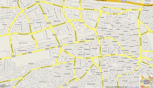
Map - Gaziantep
Map


Country - Turkey
 |
|
| Flag of Turkey | |
One of the world's earliest permanently settled regions, present-day Turkey was home to important Neolithic sites like Göbekli Tepe, and was inhabited by ancient civilisations including the Hattians, Hittites, Anatolian peoples, Mycenaean Greeks, Persians and others. Following the conquests of Alexander the Great which started the Hellenistic period, most of the ancient regions in modern Turkey were culturally Hellenised, which continued during the Byzantine era. The Seljuk Turks began migrating in the 11th century, and the Sultanate of Rum ruled Anatolia until the Mongol invasion in 1243, when it disintegrated into small Turkish principalities. Beginning in the late 13th century, the Ottomans united the principalities and conquered the Balkans, and the Turkification of Anatolia increased during the Ottoman period. After Mehmed II conquered Constantinople (Istanbul) in 1453, Ottoman expansion continued under Selim I. During the reign of Suleiman the Magnificent, the Ottoman Empire became a global power. From the late 18th century onwards, the empire's power declined with a gradual loss of territories. Mahmud II started a period of modernisation in the early 19th century. The Young Turk Revolution of 1908 restricted the authority of the Sultan and restored the Ottoman Parliament after a 30-year suspension, ushering the empire into a multi-party period. The 1913 coup d'état put the country under the control of the Three Pashas, who facilitated the Empire's entry into World War I as part of the Central Powers in 1914. During the war, the Ottoman government committed genocides against its Armenian, Greek and Assyrian subjects. After its defeat in the war, the Ottoman Empire was partitioned.
Currency / Language
| ISO | Currency | Symbol | Significant figures |
|---|---|---|---|
| TRY | Turkish lira | ₺ | 2 |
| ISO | Language |
|---|---|
| AV | Avar language |
| AZ | Azerbaijani language |
| KU | Kurdish language |
| TR | Turkish language |